Acres: Land Data & Parcel Maps
- 3.9
- Rating
- 500.00K
- Installs
- Free
- Price

 Analysis by App-foxy
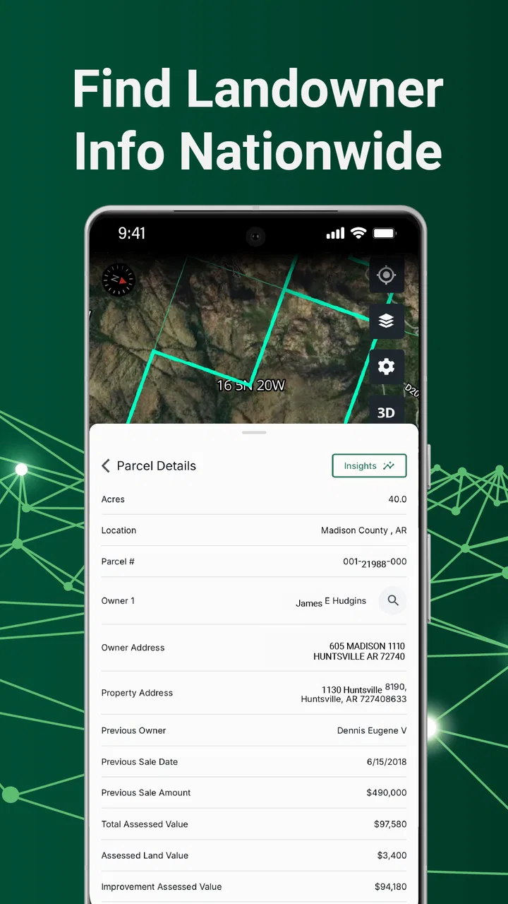
I approached Acres: Land Data & Parcel Maps as a practical property-research tool rather than a full real-estate platform. Its focus is straightforward: helping me inspect property lines, look up owner information, and browse land listings from a phone. That makes it interesting for buyers, rural property owners, investors, agents, and anyone who needs a quick first look at land without opening a desktop mapping service.
My overall impression is that Acres is most useful at the beginning of a property investigation. It can help me understand how parcels relate to roads, neighboring lots, and surrounding land before I spend time on calls, visits, or formal records searches. I would not treat a phone-based parcel view as the final word on a boundary or ownership question, but I do see value in having this kind of information available during an everyday decision.
How Acres fits into real property research
Acres.com develops the app, which belongs in the business category rather than the general navigation or social-app space. That distinction matters because the app is built around property information and land discovery, not simply getting me from one address to another. The store summary describes the core experience well, but the practical value comes from how those tools fit into a workflow.
You May Also Like

 Blood Strike: 2.5 Anniversary
Blood Strike’s Loadouts Turn Every Drop Into a Tactical Gamble
A close look at Blood Strike’s custom loadouts: how fast access to signature weapons reshapes its battle royale rhythm, rewards preparation, and narrows the gap between fights.

 Pandora - Music & Podcasts
Pandora’s Music Is Easy to Start, but Harder to Recover
Pandora’s strength is its low-effort path from a seed to a station. Its weak spot is how much confidence it asks you to place in connection, setup, and quiet recovery.

 8 Ball Pool
 Is Built on Rivalries, Rematches, and Routine
A close look at the rivalries, rematches, shared routines, and unanswered safety questions that turn a quick pool match into a persistent mobile community.

 Samsung Music
’s Quiet Strength Is Playing What You Already Own
Its reach comes less from spectacle than from dependable access to a personal library. That simplicity is both the app’s strongest retention engine and its ceiling.

 AccuWeather: Weather Radar
AccuWeather Review: A Quick, Clear Forecast for Everyday Decisions
For everyday plans, the best forecast is the one you can understand quickly. AccuWeather makes rain timing, radar, and local conditions easy to act on, with a few trade-offs.

 Hill Climb Racing
Why Hill Climb Racing Still Turns Crashes Into One More Run
A tiny car, a bumpy hill and one more upgrade: Hill Climb Racing keeps resurfacing because its simple chaos makes every near-miss feel personal.
More From Our News Desk



For example, imagine I am considering a rural parcel advertised online. Before arranging a viewing, I can use Acres to study the apparent parcel shape, see what land surrounds it, and investigate the ownership information connected with the property. I can then compare that context with the listing description and prepare more focused questions for the seller or agent. That is a better use of the app than expecting it to replace a survey, title search, or legal review.
The same workflow can help an existing landowner. If I want to understand where my property sits in relation to nearby parcels, the map can act as a convenient reference while I am away from a computer. It may also help me identify neighboring properties when planning a conversation about access, fencing, shared roads, or a possible purchase. The important habit is to use the screen as a research aid, not as proof that settles a dispute.
Land listings give the app another practical angle. Instead of searching only by a street address, I can browse with a broader land-oriented mindset: location, surrounding parcels, and the type of property that might fit a longer-term plan. This is especially useful for people who are still exploring possibilities and do not yet have one exact property in mind.
What I found useful during a normal search
The strongest part of the experience is the connection between map context and property research. A listing on its own can make land look isolated, while a parcel map encourages me to consider the neighboring lots and the shape of the area. That wider view is valuable when evaluating whether a property feels practical for farming, recreation, a future home, or investment.
I also like the idea of using ownership lookup as a preparation step. If I am researching several neighboring parcels, having owner information associated with the map can help me organize the next stage of research. I can note which parcels deserve closer attention and avoid making a call before I understand the basic layout. This does not eliminate the need for public records or professional verification, but it can make those later steps more efficient.
A less obvious benefit is that the app can reduce premature enthusiasm. A listing may look attractive until the surrounding parcel pattern raises questions about access, nearby development, or the relationship between lots. I would rather notice those questions on a phone while comparing several candidates than after traveling a long distance to see one property.
Another useful habit is to separate discovery from confirmation. I use the app to create a shortlist and identify questions. I would then confirm important details through the relevant official records, the seller, a title professional, or a licensed surveyor. That two-stage approach gives Acres a realistic role and prevents the convenience of a map from becoming overconfidence.
Trust starts with what the app lets me control
Property research can involve sensitive information because owner details and land locations are not merely abstract map labels. When I use an app in this category, I pay attention to what I am actively choosing to view, what I am searching for, and whether the experience encourages careful interpretation. Acres earns more trust when I treat its tools as visible research functions rather than assuming that every result is complete or legally decisive.
The main user choices are clear in the product’s purpose: I decide which land area to inspect, which parcel to select, whether to look up owner information, and whether to browse listings. Those choices give the experience a practical, deliberate character. I am not opening the app just to scroll through unrelated content; I am directing the search toward a property question.
Still, I would be careful at moments when the app displays information about another person’s property. I would use owner lookup for legitimate research, such as understanding a parcel before contacting the appropriate party, rather than treating it as a shortcut for intrusive investigation. A responsible workflow also means avoiding assumptions based on a name match or a map label alone.
I would also review the app’s current permission and privacy screens on my own device before using it extensively. Those screens are where I can see the choices presented to me at installation and during use. I would not infer a privacy position from the app’s category or from the fact that it shows property information. My practical advice is to read each prompt, grant only what I understand, and revisit system controls if my use changes.
That cautious approach is particularly important when I am researching a property on behalf of someone else. I would avoid entering unnecessary personal details, keep notes limited to the transaction, and make sure any information I share with a client or colleague is clearly labeled as preliminary. The app can support a professional process, but it should not silently become the entire record of that process.
Where the experience needs careful interpretation
Parcel boundaries are visually persuasive. A line drawn on a screen can look exact even when the real-world question is more complicated. Fences, driveways, easements, access routes, and historical changes may not be resolved simply because a parcel outline appears on a map. My biggest caution is therefore not about the basic idea of the app, but about the temptation to confuse a convenient display with a legal boundary.
If I were considering a purchase, I would use Acres to prepare a checklist rather than make a final decision. I would ask whether the apparent access route is actually recorded, whether the ownership information matches the seller’s claim, and whether a professional title or survey review is needed. Those questions become especially important when a parcel has an unusual shape or borders several other properties.
Owner information also deserves a measured reading. A result can help me identify a direction for further research, but I would not assume that a displayed name answers every ownership question. Trusts, companies, transfers, multiple interests, and record timing can all affect how ownership should be understood. The app is valuable when it helps me ask better questions; it is less suitable when I need a definitive legal conclusion.
Listings require similar discipline. Browsing can reveal opportunities, but an attractive listing is still a starting point. I would check the description, location, access, restrictions, utilities, and current status through the appropriate sources before treating it as an active option. The app can make discovery faster, but it does not remove the work involved in due diligence.
There is also a practical trade-off between convenience and depth. A mobile interface is excellent when I am standing outside a property, comparing areas, or discussing a parcel in the car before a visit. It is less comfortable for building a large research file or studying complex ownership history for hours. For that work, I would prefer a desktop browser, official records system, or professional real-estate workflow alongside Acres.
Who will get the most from it
I think the app is a good match for land buyers who want a fast way to screen possibilities. It can help narrow a broad search before the more expensive stages of evaluation. Rural homeowners and recreational land users may also appreciate having parcel context available when they are thinking about neighboring lots or future plans.
Real-estate professionals could use it as a conversation aid when preparing for an initial property discussion. An agent might inspect the surrounding parcels before speaking with a client, while an investor could use the map to organize a list of candidates. The app is most useful in these situations when it supplements, rather than replaces, the professional’s established records and verification process.
It may also suit curious land shoppers who are not ready to contact anyone yet. Browsing can help me understand what types of properties appear in a region and whether a location deserves more attention. That exploratory stage is where a free app has a clear advantage: I can investigate without committing to a paid service immediately.
I would be more hesitant to recommend it as the only tool for someone facing a boundary dispute, a complicated title issue, or a high-stakes purchase. In those cases, the right answer may be an official county or land-record source, a title company, a surveyor, or a real-estate attorney. Acres can help me frame the issue, but those alternatives are better suited to authoritative resolution.
Cost, access, and the practical trade-off
Acres is free to install, which makes it easy to try during an early property search. The app is rated for Everyone, and its Android listing requires version 10 or later. It was released on September 23, 2022, and the current version is 3.5.8. Those details make it a reasonably accessible option for people using a modern Android device, while anyone with an older phone should check compatibility before planning around it.
The app has passed the half-million-install mark and holds a 4.0 average from around 2.6 thousand ratings, with roughly 779 written reviews. I read those figures as evidence of meaningful use, not as a guarantee that every search will feel equally complete. Ratings can tell me how broadly an app is being used, but they cannot settle whether a particular parcel result is sufficient for my situation.
Although the app is free, in-app purchases range from $9.99 to $89.99 per item. That changes how I would approach it. I would begin with the free experience and decide whether the available tools answer my initial question before paying for anything. If I were only checking one or two properties, a purchase might not make sense. If I were conducting repeated research, I would first make sure the added value fits my workflow rather than assuming that payment automatically provides the certainty I need.
This is one of the app’s clearest trade-offs: low-friction entry paired with the possibility of spending more as my research becomes more serious. I would keep a simple record of what I am trying to learn and only pay when a specific function saves enough time to justify the cost. That approach is more sensible than upgrading simply because a property search feels urgent.
Three habits that make the app more reliable
My first recommendation is to capture context, not just a parcel name. When I find an interesting property, I would note the surrounding roads, neighboring parcels, and the reason it caught my attention. That prevents a common mistake: returning later to a saved-looking result and forgetting which access or location detail mattered in the first place.
Second, I would compare several nearby parcels before forming an opinion. Looking at one property in isolation can hide patterns in the area. A short comparison may reveal that a supposedly unusual boundary is common locally, or that a road relationship deserves more investigation. This turns the map into a research tool rather than a simple yes-or-no screen.
Third, I would create a verification handoff. After using the app, I would write down the questions that need official confirmation: ownership, access, easements, restrictions, and the exact legal boundary. This is a small step, but it keeps the convenience of Acres from blurring the line between preliminary information and professional evidence.
I would also avoid sharing screenshots or owner details casually. If I need to discuss a property with a partner or adviser, I would share only what is relevant and explain that the app view is part of an early investigation. That protects the quality of the conversation and encourages everyone involved to verify important claims instead of repeating them as facts.
My cautious recommendation
After using the app as a property-research companion, I see a useful balance between accessibility and responsibility. Acres makes it easier to move from a vague interest in land to a more informed set of questions. Its combination of parcel maps, owner lookup, and land browsing is more practical than relying on a listing page alone, particularly when I am comparing rural properties or preparing for a first conversation.
My recommendation comes with a firm boundary: use Acres to investigate, organize, and prepare—not to replace official verification. That single rule makes the app much more valuable. It protects me from treating a visual boundary as a legal survey, a name result as complete title evidence, or a listing as a confirmed opportunity.
The free entry point is appealing, and the app’s business focus is clear. The purchase range means I would test my actual workflow before paying, especially for a one-property search. People who need quick parcel context should find a credible reason to try it, while users dealing with legal disputes or complex transactions should pair it with more authoritative services.
In the end, I would recommend Acres to a friend who wants a mobile first look at land and understands the difference between useful research and final proof. I would skip making it my only source if the decision involved substantial money, disputed boundaries, or sensitive ownership questions. Used with that level of care, the app is a convenient way to turn a property search into a more organized, better-informed process.
FAQs for Acres: Land Data & Parcel Maps
01What features does Acres: Land Data & Parcel Maps offer?
Acres provides comprehensive land data and parcel maps, offering features such as detailed property boundaries, ownership information, and land valuation. The app is equipped with tools for measuring distances and areas, and users can access historical land use data. Its intuitive interface ensures that both casual users and professionals can navigate easily.
02Is Acres: Land Data & Parcel Maps free to use?
While Acres offers a basic version for free, it also includes premium features that require a subscription. The free version provides access to essential parcel data and maps, but advanced features like detailed property reports and offline access are part of the paid plan. Users can choose the plan that best suits their needs.
03Can I use Acres offline?
Acres does offer offline access, but this feature is part of the premium subscription. With offline access, users can download maps and data to use without an internet connection, which is particularly useful for fieldwork in remote areas. This ensures that users have the information they need at all times.
04How accurate is the data provided by Acres?
Acres sources its data from reputable governmental and private databases, ensuring high accuracy and reliability. The app frequently updates its information to provide users with the most current data available. However, users should cross-verify critical data, especially for legal or professional purposes, to ensure completeness.
05Is Acres suitable for professional use?
Yes, Acres is designed to be beneficial for both casual users and professionals in fields such as real estate, farming, and land management. Its advanced tools and accurate data make it a valuable resource for professionals needing detailed land insights. The app’s user-friendly design also ensures ease of use for everyone.
Pros
- Intuitive interface for easy navigation.
- Access to detailed land parcel data.
- Offline maps for remote areas.
- Customizable layers for analysis.
- Regular updates with new features.
Cons
- Requires a stable internet for updates.
- Limited features in the free version.
- Can be data-heavy on older devices.
- Occasional GPS inaccuracies.
- Subscription model may be costly.

Acres: Land Data & Parcel Maps
Gallery